


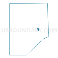
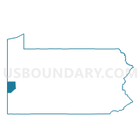
CONWAY VTD 01, Beaver County, Pennsylvania
About
Outline

Summary
| Unique Area Identifier | 657109 |
| Name | CONWAY VTD 01 |
| County | Beaver County |
| State | Pennsylvania |
| Area (square miles) | 0.85 |
| Land Area (square miles) | 0.67 |
| Water Area (square miles) | 0.18 |
| % of Land Area | 78.52 |
| % of Water Area | 21.48 |
| Latitude of the Internal Point | 40.66330420 |
| Longtitude of the Internal Point | -80.24310090 |
Maps

Graphs
Select a template below for downloading or customizing gragh for CONWAY VTD 01, Beaver County, Pennsylvania


Neighbors
Neighoring Voting District (by Name) Neighboring Voting District on the Map
- CENTER TWP VTD 03, Beaver County, PA
- CONWAY VTD 02, Beaver County, PA
- ECONOMY VTD 04, Beaver County, PA
- FREEDOM Voting District, Beaver County, PA
- HOPEWELL TWP VTD 01, Beaver County, PA
- MONACA WD 02, Beaver County, PA
Top 10 Neighboring County Subdivision (by Population) Neighboring County Subdivision on the Map
- Hopewell township, Beaver County, PA (12,593)
- Center township, Beaver County, PA (11,795)
- Economy borough, Beaver County, PA (8,970)
- Monaca borough, Beaver County, PA (5,737)
- Conway borough, Beaver County, PA (2,176)
- Freedom borough, Beaver County, PA (1,569)
Top 10 Neighboring Place (by Population) Neighboring Place on the Map
- Economy borough, PA (8,970)
- Monaca borough, PA (5,737)
- Conway borough, PA (2,176)
- Freedom borough, PA (1,569)
Top 10 Neighboring Unified School District (by Population) Neighboring Unified School District on the Map
- Ambridge Area School District, PA (23,827)
- Hopewell Area School District, PA (18,145)
- Center Valley School District, PA (18,095)
- Freedom Area School District, PA (11,105)
Top 10 Neighboring State Legislative District Lower Chamber (by Population) Neighboring State Legislative District Lower Chamber on the Map
- State House District 16, PA (58,551)
- State House District 15, PA (57,350)
- State House District 14, PA (55,975)
Top 10 Neighboring State Legislative District Upper Chamber (by Population) Neighboring State Legislative District Upper Chamber on the Map
Top 10 Neighboring 111th Congressional District (by Population) Neighboring 111th Congressional District on the Map
Top 10 Neighboring Census Tract (by Population) Neighboring Census Tract on the Map
- Census Tract 6032.02, Beaver County, PA (7,089)
- Census Tract 6049.01, Beaver County, PA (4,171)
- Census Tract 6038.01, Beaver County, PA (2,822)
- Census Tract 6036, Beaver County, PA (2,176)
- Census Tract 6034, Beaver County, PA (1,892)
- Census Tract 6035, Beaver County, PA (1,569)